Lorem ipsum dolor sit amet, consectetur adipiscing
elit.
Inter tropical Convergence Zone (ITCZ) and Equatorial Currents
By
14/11/2018
Share this:
Inter tropical Convergence Zone (ITCZ) and Equatorial Currents
Inter tropical Convergence Zone (ITCZ) and Equatorial Currents
The tropical ocean encompasses broad areas of the Atlantic, Pacific, and Indian Ocean basins and is closely linked to the tropical atmosphere.
Trade Winds:-
The prevailing surface winds over the tropical ocean are the trade winds that blow persistently from the northeast (toward the southwest) in the Northern Hemisphere and from the southeast (toward the northwest) in the Southern Hemisphere.
The name for these winds was coined by sea captains who sailed for trading companies and took advantage of their persistent speed and direction when crossing the ocean.
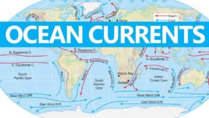
Trade winds drive both North and South Equatorial Currents westward, thus transporting warm ocean-surface waters in that direction.
Equatorial Counter Currents and Equatorial Under Currents return some warm waters eastward.
Counter Currents flow along the surface whereas Under Currents flow at greater depths below the surface.
Inter tropical Convergence Zone (ITCZ) and Equatorial Currents
Inter tropical Convergence Zone (ITCZ) and Equatorial Currents
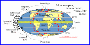
Near the equator, from about 5° north and 5° south, the northeast trade winds and southeast trade winds converge in a low pressure zone known as the Inter tropical Convergence Zone or ITCZ.
The trade winds of the two hemispheres converge in a narrow east-west zone located near the equator known as the Inter tropical Convergence Zone (ITCZ).
The ITCZ is an important component of the planetary-scale atmospheric circulation that is particularly well defined over the tropical ocean.
Warm and humid air ascending in the ITCZ gives rise to clusters of showers and thunderstorms that produce locally heavy rainfall.
Why do ITCZ do not have a consistent location ?
The Intertropical Convergence Zone is characterized by inconsistent location around the equator.
As the Earth moves with the seasons, the area which receives the highest amount of heat energy from the sun varies.
The thermal equator around which the ITCZ forms thus moves, depending on the season.
In some cases, this shift can result in the complete reversal of normal trade wind patterns, particularly in the Indian Ocean.
Role of ITCZ in monsoons ?
Inter Tropical Convergence Zone is a low pressure zone located at the equator where trade winds converge, and so, it is a zone where air tends to ascend.
In July, the ITCZ is located around 20ºN latitudes (over the Gangetic plain), sometimes called the monsoon trough.
This monsoon trough encourages the development of thermal low over north and northwest India.
Due to the shift of ITCZ, the trade winds of the southern hemisphere cross the equator between 40ºE and 60ºE longitudes and start blowing from southwest to northeast due to the Coriolis force. It becomes southwest monsoon.
In winter, the ITCZ moves southward, and so the reversal of winds from northeast to south and southwest, takes place. They are called northeast monsoons.
Why do Doldrums occur ?
In the Inter tropical Convergence Zone, the northern and southern trade winds come together.
Because of the rotation of the Earth, the winds cannot really cross the equator without losing energy.
Instead of continuing over the Earth horizontally, the winds thus move vertically toward the upper atmosphere.
The heating of the Earth’s ocean currents by the sun assists in this process, making the air warmer and letting it rise.
The result is that the Inter tropical Convergence Zone has low air pressure near the Earth’s surface.
The lack of horizontal wind movement in the region caused sailors to nickname the Inter tropical Convergence Zone, “the doldrums.
For mariners the region of the tropical ocean near the equator is known as the doldrums, feared by the captains of sailing ships because of light and variable winds.
Seasonally, the ITCZ moves with the sun, shifting northward during the Northern Hemisphere spring and southward during the Northern Hemisphere autumn but generally remaining north of the equator, especially over the Atlantic Ocean.
Consequently, the eastward-flowing Equatorial Counter Current, separating the surface current systems of the two hemispheres, also lies mostly just north of the equator.
The South Equatorial Current crosses the equator in the Atlantic and to a lesser extent in the Pacific. In this way, it transports surface waters and heat into the Northern Hemisphere. The return flow is through subsurface currents.
The cape at the easternmost point of South America diverts part of the flow of the South Equatorial Current into the southward flowing Brazil Current. The remainder continues northwestward along South America’s northeast coast into the Caribbean Sea.
The islands of Indonesia mark the boundary between the Indian and Pacific Oceans but do not completely block the flow of seawater between the two ocean basins.
Warm, low salinity waters from the Pacific are transported into the Indian Ocean’s South Equatorial Current.
These waters flow through the many passages between the thousands of Indonesian islands and replenish the large amounts of water removed by evaporation from the northern Indian Ocean.
The summer Asian monsoon circulation transports this water vapor over India and Southeast Asia where it falls as torrential rains. After flowing westward across the Indian Ocean, these waters enter the South Atlantic via the Agulhas Current flowing around southern Africa.
The summer monsoon is associated with heavy rainfall. It usually happens between April and September.
As winter ends, warm, moist air from the southwest Indian Ocean blows toward countries like India, Sri Lanka, Bangladesh, and Myanmar. The summer monsoon brings a humid climate and torrential rainfall to these areas.
The Indonesian islands partially block the inter-ocean flow, which leads to an accumulation of warm surface waters in the western equatorial Pacific Ocean that is linked to El Niño/La Niña.


.png)