State of Forest Report 2019 Summary Volume I
 It is the 16th biennial assessment of India’s forests by Forest Survey of India, an organisation under the Ministry of Environment, Forest and Climate Change.
- FSI undertakes National Forest Inventory to assess the growing stock in forests and TOF (Tree Outside Forest), bamboo resource, carbon stock and to assess the dependence of the people living in Forest Fringe Villages for fuelwood, fodder, small timber and bamboo.
- In the current ISFR, a new chapter ‘Forest Types and Biodiversity’ has been added
Key Findings
- The Total Forest and Tree cover is 24.56% of the geographical area of the country.
- The Total Forest cover is 7,12,249 sq km which is 21.67% of the geographical area of the country.
- The Tree cover is 2.89% of the geographical area of the country.
- As compared to ISFR 2017 the current assessment shows an increase of
- 0.65% of forest and tree cover put together, at the national level
- 0.56% of forest cover
- 1.29% of tree cover
- Change in Recorded forest Area/Green Wash (RFA/GW) as compared to previous assessment of 2017.
- Forest cover within the RFA/GW: a slight decrease of 330 sq km (0.05%)
- Forest cover outside the RFA/GW: there is an increase of 4,306 sq km.
- The top five States (UT) in terms of increase in forest cover: Karnataka>Andhra Pradesh>Kerala>Jammu & Kashmir>Himachal Pradesh.
- Forest cover in the hill districts is 40.30% of the total geographical area of these districts. An increase of 544 sq km (0.19%) in 140 hill districts of the country.
- The total forest cover in the tribal districts is 37.54% of the geographical area of these districts.
- Total forest cover in the North Eastern region is 65.05% of its geographical area. The current assessment shows a decrease of forest cover to the extent of 765 sq km (0.45%) in the region. Except Assam and Tripura, all the States in the region show decrease in forest cover.
- Mangrove cover in the country has increased by 1.10% as compared to the previous assessment.
- Wetlands cover 3.83% of the area within the RFA/GW of the country. Amongst the States, Gujarat has the largest area of wetlands within RFA in the country followed by West Bengal.
- Dependence of fuelwood on forests is highest in the State of Maharashtra, whereas, for fodder, small timber and bamboo, dependence is highest in Madhya Pradesh.
- It has been assessed that the annual removal of the small timber by the people living in forest fringe villages is nearly 7% of the average annual yield of forests in the country.
Introduction
- Forest Cover: The forest canopy area covered on the ground irrespective of the legal status of land. It includes all tree patches which have canopy density more than 10% and area of 1 ha or more in size.
- Canopy Density: It is defined as the proportion of an area in the field/ground, that is covered by the crown of trees.
- Recorded Forest Area (RFA):
- Forest Area (or recorded forest area) refers to all the geographic areas recorded as forest in government records.
- Recorded forest areas comprises Reserved Forests (RF) and Protected Forests (PF), which have been constituted under the provisions of Indian Forest Act, 1927.
- Besides RFs and PFs, the recorded forest area may include all such areas, which have been recorded as forests under any State Act or local laws or any revenue records.
- TOF (Trees Outside Forest): Trees found outside the recorded forest areas. TOF refers to all trees growing outside RFA irrespective of patch size which could also be larger than 1 ha.
- Tree cover: All patches of trees occurring outside RFA which are of size less than 1 ha including the scattered trees. Tree cover forms an important part of the trees outside forests (TOF). Therefore, tree cover can be considered as a subset of TOF.
- According to the Global Forest Resource Assessment (FRA) done by Food and Agriculture Organisation (FAO) once every five years, India has 2% of the Global forest area, standing at 10th position among the top ten countries in respect of forest area. Russia Federation tops the list with 20% of the global forest cover.
Chapter 2- Forest Cover
- National Forest Policy of India, 1988 envisages a goal of achieving 33% of geographical area of the country under forest and tree cover.
- The main objectives:
- to monitor forest cover and changes therein at the National, State and District levels.
- to generate information on forest cover in different density classes and changes therein.
- to produce forest cover and other thematic maps derived from it for the whole country.
- to provide a primary base layer for assessment of different parameters including growing stock, forest carbon etc.
- to provide information for international reporting.
- Forest cover: Includes all lands having trees more than one hectare in area with tree canopy density of more than 10%, irrespective of ownership, legal status of the land and species composition of trees.
- Very Dense Forest: All lands with tree canopy density of 70% and above. The relative composition of forest cover under this category is 3.02%
- Moderately Dense Forest: All lands with tree canopy density of 40% and more but less than 70%. Forest cover under this category is 9.39%
- Open Forest: All lands with tree canopy density of 10% and more but less than 40 %. Forest cover of 9.26% falls under this category.
- Scrub Forest: Lands with canopy density less than 10%. Geographical area under this category is 1.41%.
- Non-forest: Lands not included in any of the above classes (includes water). Geographical area under the non-forest category is 76.92%.
- Largest forest cover in India: Madhya Pradesh > Arunachal Pradesh > Chhattisgarh > Odisha > Maharashtra
- Forest cover as percentage of total geographical area: Mizoram (85.41%) > Arunachal Pradesh (79.63%) > Meghalaya (76.33%) > Manipur (75.46%) > Nagaland (75.31%).
- There is an overall gain of 3,976 sq km of forest cover in the country as compared with the ISFR 2017 report.
- States/UTs showing significant gain in forest cover: Karnataka > Andhra Pradesh > Kerala > J&K
- States showing loss in forest cover: Manipur > Arunachal Pradesh > Mizoram
- There is an overall increase in forest cover in the tribal districts by 1,181 sq km.
- There are 218 tribal districts in 27 States/UTs as identified by the Government of India under the Integrated Tribal Development Programme.
- Gujarat has the largest area of the wetlands within RFA/GW in the country followed by West Bengal. Wetlands within forest areas form important ecosystems.
- Among the smaller States/UTs, Puducherry followed by A&N Islands have large areas of wetlands within RFA/GW.
- In the country as a whole there are 62,466 wetlands covering 3.83% of the area within the RFA/GW areas of the country.
Chapter 3- Mangrove Cover
- Mangroves are a diverse group of salt-tolerant plant communities of tropical and subtropical regions of the world which can survive the limiting factors imposed by lack of oxygen, high salinity and diurnal tidal inundation.
- According to Champion & Seth Classification (1968) Mangroves are included in Type Group-4 Littoral & Swamp Forests
- IMPORTANCE OF MANGROVES
- Mangroves have a complex root system which is very efficient in dissipating the sea wave energy thus protecting the coastal areas from tsunamis, storm surge and soil erosion. Their protective role has been widely recognized especially after the devastating Tsunami of 2004.
- Mangrove roots slow down water flows and enhance sediment deposition. Therefore, they act as a zone of land accretion due to trapping of fine sediments including heavy metal contaminants. They also arrest coastal erosion and sea water pollution.
- They act as a fertile breeding ground for many fish species and other marine fauna.
- They act as an important source of livelihood for the coastal communities dependent on collection of honey, tannins, wax and fishing.
- Mangroves are important carbon sink.
- About 40% of the world’s Mangrove Cover is found in South East Asia and South Asia.
- The mangrove cover in India is 4,975 sq km, which is 0.15% of the country’s total geographical area.
- Increase in the mangrove cover as compared to 2017 assessment: 54 sq km
- Among the states and UTs, West Bengal has the highest percentage of area under total Mangrove cover followed by Gujarat and Andaman Nicobar Islands.
- Top three states showing Mangrove cover increase: Gujarat > Maharashtra > Odisha
-
- States and UTs with maximum species diversity of;
- Trees: Karnataka,
- Shrubs: Arunachal Pradesh,
- Herbs: Jammu & Kashmir.
- State with maximum species richness for Maximum richness of species taking all the three types of plants: Arunachal Pradesh > Tamil Nadu > Karnataka
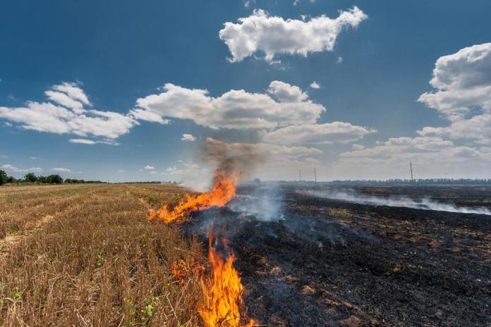
Forest Fire & Monitoring
National Action Plan on Forest Fires, 2018
- MoEF&CC, has come up with the National Action Plan on Forest Fires, 2018 to revamp forest fire management in the country.
- Main objectives
- informing,
- enabling and
- empowering forest fringe communities and
- incentivizing them to work in tandem with the State Forest Departments (SFDs).
- The plan proposes nine strategies to address the issue, including establishment of a “Centre of Excellence on Forest Fire Management”at FSI.
- A joint study report of MoEF&CC and World Bank titled “Strengthening Forest Fire Management in India” released in June 2018 revealed that in the year 2000, 20 districts, representing 3% of India’s land area and 16% of forest cover accounted for 44% of all fire detections.
- The upgraded version of the Forest Fire Alert System version 3.0 (FAST 3.0) was released on16th January, 2019 with a separate activity of monitoring large forest fires.
- Forest Cover of States & UTs under different fire prone classes:
- Extremely Fire Prone: Mizoram > Tripura
- Very Highly Fire Prone: Mizoram > Manipur
- Highly Fire Prone: Nagaland > Manipur
- Moderately Fire Prone: Punjab > Nagaland
- It is seen that most of the fire prone forest areas are found in the northeastern region and the central part of the country.
Tree Cover
- The total tree cover of the country has been estimated to be 95,027 sq km.
- There is an increase of 1,212 sq km in the extent of tree cover as compared to the 2017 assessment.
- State-wise estimates of Tree Cover:
- Maximum Tree Cover: Maharashtra > Madhya Pradesh > Rajasthan > J&K
- Maximum Tree Cover as percentage of geographical area: Chandigarh > Delhi > Kerala > Goa
- State-wise estimates of Tree Outside Forest (TOF)
- Maximum extent of TOF: Maharashtra > Odisha > Karnataka
- Maximum extent of TOF as percentage of geographical area: Kerala > Goa > Nagaland.
National Forest Inventory (NFI)
- It is a major forest resource assessment activity carried out by FSI.
- The primary objective is to assess growing stock of trees, number of trees, bamboo, soil carbon, occurrence of NTFP (Non-Timber Forest Products) and invasive species and other parameters depicting growth & health of forest.
- The NFI has three components, Forest Inventory, TOF (Rural) Inventory and TOF (Urban) Inventory.
Chapter 8- Bamboo Resources of the Country
- In India, bamboo grows naturally throughout the country except in Kashmir region. India is home to about 125 indigenous and 11 exotic species of bamboo from 23 genera.
- Bamboo contributes significantly to the social, economic & ecological development of any region.
- Bamboo bearing area of the country: 16.00 million hectare.
- Increase in bamboo bearing area: 0.32 million hectare, as compared ISFR 2017.
- States with maximum bamboo bearing area: Madhya Pradesh > Maharashtra > Arunachal Pradesh > Odisha.
- Maximum occurrence of pure bamboo: Maharashtra > Madhya Pradesh > Chhattisgarh.
Chapter 9- Carbon Stock in India’s Forest
- Total carbon stock in the country’s forest: estimated to be 7,124.6 million tonnes.
- There is an increase of 42.6 million tonnes in the carbon stock of the country as compared to the last assessment of 2017.
- State-wise Maximum carbon stock: Arunachal Pradesh > MadhyaPradesh > Chhattisgarh > Maharashtra
- State-wise Maximum per hectare carbon stock: Sikkim > Andaman & Nicobar Islands > Jammu & Kashmir > Himachal Pradesh > Arunachal Pradesh
- Soil organic carbon is the largest pool of forest carbon followed by Above Ground Biomass (AGB), Below Ground Biomass (BGB), Litter and dead wood.
Chapter 10- People & Forests
- As per the Census 2011 nearly 1,70,000 villages are located in the proximity of forest areas and are termed Forest Fringe Villages (FFVs).
- The study conducted by FSI assessed the dependence of the people living in proximity to forests in terms of removal of:
- Quantity of fuelwood
- Quantity of fodder
- Quantity of small Timber
- Quantity of bamboo
- Top 3 states in dependence on forests for
- Fuelwood: Maharashtra > Odisha > Rajasthan
- Fodder: Madhya Pradesh > Maharashtra > Gujarat
- Small Timber: Madhya Pradesh > Gujarat > Maharashtra
- Bamboo: Madhya Pradesh > Chhattisgarh > Gujarat


.png)