Polar Vortex and Its effects
What is the News?
- A record-breaking cold wave has swept through the US Midwest, with 22 states hitting sub-zero temperatures. Among cities, Chicago dropped to a low of -30°C, slightly above the city’s lowest-ever reading of -32°C from January 1985.
- The extreme cold has been caused by a blast of Arctic air, which in turn is a result of what is known as a “polar vortex” event.
 What is a Polar Vortex?
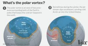
- A polar vortex is an upper-level low-pressure area lying near one of the Earth’s poles.
- There are two polar vortices in the Earth’s atmosphere, overlying the North and South Poles.
- During winter, the polar vortex at the North Pole expands, sending cold air southward.
- It is described as a whirling cone of low pressure over the poles that is strongest in the winter months due to the increased temperature contrast between the polar regions and the mid-latitudes, such as the US and Europe.
- It ALWAYS exists near the poles, but weakens in summer and strengthens in winter.
- The term “vortex” refers to the counter-clockwise flow of air that helps keep the colder air near the Poles.
- Usually, when the vortex is strongest, cold air is less-likely to plunge deep into North America or Europe.
Effects of Polar Vortex
- When the polar vortex is strong, temperatures are mild in the mid-latitudes across the Eastern US and Northern Eurasia and this creates strong low pressure in the Arctic region.
- During strong polar vortex, the air flow is fast and in a direction from west to east.
- When the polar vortex is weak or “perturbed”, the flow of air is weaker and meanders north and south (rather than west to east).
- During a weak polar vortex, high pressure occurs in the Arctic region and temperatures tend to be cold across the Eastern US and northern Europe and Asia.

 What is a Polar Vortex?